J2-9251: M3Sat – Methodology of Multitemporal Multisensor Satellite Image Analysis
| Project Title | M3Sat – Methodology of Multitemporal Multisensor Satellite Image Analysis |
| Project team: | Krištof Oštir, Anka Lisec, Jernej Tekavec, Tatjana Veljanovski, Aleš Marsetič, Maja Somrak |
| Duration: | 48 months
July 1st, 2018 – June 30th, 2022 |
| Project Code: | J2-9251 |
| Lead partner: | UL FGG |
| Project leader: | Krištof Oštir |
| Partners: | Research Centre of the Slovenian Academy of Sciences and Arts |
| Source of finance: | Slovenian Research Agency |
| Key words: | remote sensing, satellite data, high resolution, data harmonization, time series, time series analysis |
Description
To properly analyse Earth surface phenomena, calibrated and consistent satellite data must be provided. The aim of the project was to evaluate existing methods for time series analysis, including the impact of time series data characteristics (radiometric characteristics and density) on analysis and use.
The project focused on coordination between sensors, modelling of time series and evaluation of the most critical points in spatio-temporal analyses. The main results of the project are the following.
- The most comprehensive library of Sentinel-1, Sentinel-2, Landsat and PlanetScope satellite images for Slovenia.
- Procedures for preparation and different time series of satellite data, i.e., single sensor, multisensor, combined.
- Satimagets library – we have developed a method and software for a general procedure for combining and calibrating optical data.
- The developed time series and time series processing algorithms were implemented and evaluated in seven study cases.
The project conducted numerous experiments that provided valuable insights into the development of new approaches, the possibilities of harmonising satellite data, the usefulness of time series, and the challenges and directions for the development of time series analysis that remain for further research.
Project goals
To achieve the main objective, the project defined five goals:
- development of general methods for data reconciliation between sensors,
- harmonisation of data from different sensors into a single, long and dense time series,
- transition to cloud-based processing,
- systematic evaluation of state-of-the-art algorithms for time series analysis and
- observation of selected events and phenomena in Slovenia.

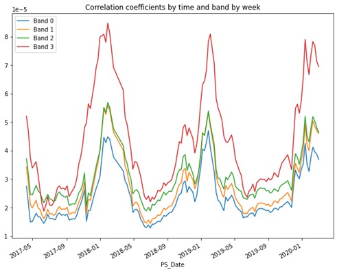
Changing the correlation coefficient across channels over time.

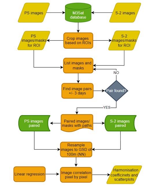
The process of preparation and harmonization of satellite data.
Project work packages
Work Package 1 (WP1): Data collection and analysis of multi-sensor fusion and calibration approaches;
Work Package 2 (WP): Generation of long and dense time series;
Work Package 3 (WP3): Time series analysis;
Work Package 4 (WP4): Evaluation of the time series processing methodology for selected applications;
Work Package 5 (WP5): Project management.
Results
Reviewed papers published in international journals:
- Pehani, P., Veljanovski T., Kokalj, Ž., Oštir, K. 2022. Šest let arhiva podatkov Sentinel-2 za Slovenijo. | Six years of Sentinel-2 archive of Slovenia. Geodetski vestnik, 66 (2). COBISS.SI-ID 115534595
- Veljanovski, T., Čotar, K., Marsetič, A., 2019. Large scale mosaicing and compositing of PROBA-V satellite images. Geodetski glasnik 50. SI-ID 45702189
- Fetai B., Račič M., Lisec A., 2021. Deep Learning for Detection of Visible Land Boundaries from UAV Imagery. Remote Sensing. COBISS.SI-ID 64902403
- Kanjir, U., Đurić, N., Veljanovski, T., 2018. Sentinel-2 based temporal detection of agricultural land use anomalies in support of common agricultural policy monitoring. ISPRS international journal of geo-information.SI-ID 43706157
- Račič, M., Oštir, K., Peressutti, D., Zupanc, A., Čehovin Zajc, L., 2020. Application of temporal convolutional neural network for the classification of crops on Sentinel-2 time series. ISPRS Annals of the Photogrammetry, Remote Sensing and Spatial Information Sciences. SI-ID 95106563
- Potočnik Buhvald, A,. Račič, M., Immitzer, M., Oštir, K., Veljanovski, T., 2022. Grassland Use Intensity Classification Using Intra-Annual Sentinel-1 and -2 Time Series and Environmental Variables. Remote sensing. COBISS.SI-ID 115487491
- Marsetič, A., Kanjir, U., 2022. Klasifikacija pokrovnosti z uporabo globokega učenja na časovnih vrstah podatkov PlanetScope. Geografski informacijski sistemi v Sloveniji: Preteklost in prihodnost. DOI: https://doi.org/10.3986/9789610506683
Reports
- Čož, N., Veljanovski, T., Kokalj, Ž. 2020. Testing of the compositing algorithm for Sentinel-2 products. Technical report. COBISS.SI-ID 14932483
- Pehani, P., Čož, N., Veljanovski, T., Kokalj, Ž., Lisec, A., Oštir, K. 2020. Automatic processing of Sentinel-1 sigma and coherence. Technical report. COBISS.SI-ID 88491523
- Veljanovski, T., Potočnik Buhvald, A., Račič, M., Pehani, P., Oštir, K., 2020. Testiranje možnosti in izvedba kartiranja traviščnih habitatnih tipov z daljinskim zaznavanjem s poudarkom na ločevanju intenzivnih in ekstenzivnih travnikov. Final report. SI-ID 116965123
- Pehani, P., Čož, N., Veljanovski, T., Kokalj, Ž., Lisec, A., Oštir, K. 2021. Automatic processing of Sentinel-1 sigma and coherence including special cases and anomalies: technical report, version 2. Technical report. COBISS.SI-ID 88491523
GitHub repository
- Oštir, K., Račič, M., Fetai, B., Veljanovski, T., 2021. Satellite image time series. [S. l.: s. n.], cop. 2021. https://github.com/EarthObservation/satimagets. COBISS.SI-ID 116535811

