
J2-3055: ROVI – Innovative radar and optical satellite image time series fusion and processing for monitoring the natural environment
| Project title: | ROVI – Innovative radar and optical satellite image time series fusion and processing for monitoring the natural environment |
| Project team UL: | Krištof Oštir, Anka Lisec, Jernej Tekavec, Bujar Fetai, Urška Drešček, Ana Potočnik Buhvald, Matej Račič Tatjana Veljanovski, Žiga Kokalj, Nejc Čož, Aleš Marsetič, Urška Kanjir, Liza Stančič, Andrej Kobler, Mitja Skudnik, Jernej Jevšenak |
| Duration: |
36 months 1. 10. 2021 – 30. 9. 2024 |
| Project code: | J2-3055 |
| Lead partner | University of Ljubljana, Faculty of Civil and Geodetic Engineering |
| Project leader at UL: | Prof. Krištof Oštir |
| Partners: |
Research Centre of the Slovenian Academy of Sciences and Arts
|
| Source of finance: |
|
| Key words: | earth observation, satellite image time series, data fusion, radar, optical, machine learning, vegetation, grassland, forests, wetlands |

Description
Earth observation plays an important role in achieving sustainable development by providing spatial information to support policy, planning, and decision making. The serious changes in the natural environment are becoming societal problems hence detailed and upto- date information is essential. The proposed project aims to contribute to this challenge by developing advanced solutions for monitoring and predicting processes in the natural environment. We focus on satellite-based observation of grasslands, wetlands, and forests, because these are valuable habitats as well as some of the most important natural carbon sinks. Accurate and timely information about their condition can improve the management and long term sustainability of these areas.
Main goals
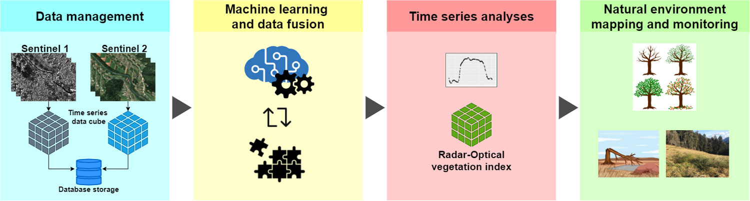
The project will focus on data collected by optical Sentinel-2 satellites and radar Sentinel-1 satellites of the European Copernicus programme.
- The main research goal is to combine the very different optical and radar time series of satellite data. This fusion can overcome the problem of missing data when only optical images are used (loss of observations due to cloud cover), and thus greatly improve the ability to observe vegetation with satellite data.
- Identifying vegetation types, as well as observing the development or response of vegetation is significantly more successful and accurate if important phases in the phenological development can be identified in the time series of satellite data. In this light, our next objective is to provide ordered and validated time series of optical and radar data, so-called analysis-ready data, in addition to open-source vegetation mapping tools. To achieve this objective, we will explore multi-sensor satellite data fusion with machine learning approaches, time series analysis for vegetation observation, and knowledge extraction with data mining.
- The reliability of the results will be ensured by calibration and validation of data and methods with verified reference data (field observations). We will develop tools for key tasks of monitoring the natural environment, such as tools for predicting vegetation species and vegetation growth, and tools for vegetation-specific phenology metrics.
Project work packages:
The research part of the project will be carried out in five interlinked thematic work packages (WP1-WP5) and a separate work package is dedicated to project coordination and dissemination (WP6).
- In WP1 we will prepare a collection of Sentinel-1 and Sentinel-2 satellite data and related products, and organise the data in a PostgreSQL database with other relevant data (e.g., in-situ observations).
- In WP2 we will analyse and improve machine learning methods for time series generation, analysis, and validation.
- WP3 is dedicated to data fusion and time series analysis – to achieve this, we will develop a novel radar optical vegetation index (ROVI), and apply advanced machine learning methods for time series analysis defined in WP2.
- WP4 will improve spatio-temporal models, calibration, and validation of different satellite time series to define new descriptors and workflows for phenology analyses.
- In WP5, we will use radar optical satellite time series for mapping large heterogeneous natural areas. Mapping accuracy will be evaluated, and reliability will be provided as an important output.